|
Home Links
Cone Search (uses cookies)
Name look up :
(paste J2000 below) |
|
|
Separate VLA images:
Browse:
- (pop-up window)
- (in the browser)
-
-
-
-
Version 2022-Sep-02 [an error occurred while processing this directive]
|
NRAO VLA Archive Survey Images Pilot Page
[PURPOSE]
[PROJECT]
[POSITION]
[plots]
[NVAS CONTACT]
[NVAS MAIN PAGE]
Guide to the file VLA Archive Image download/browse system
Purpose
Here you can browse the files in the archive, in case you're not
looking for images but for uvdata (e.g. if you want to combine
multiple calibrated data sets), or want to see the logs for a
particular pipelined experiment. Have fun!
The files come in two categories
- Project files are related to a (multi-source) observing run
- Position files are related to a (single-source) sky location
- And the position files come with additional (source visibility) plots
Project Files
These multi-source files are archived under a project name directory
and contain all files related to the project, regardless of anything
else than the project name (eg observed on different dates,
frequencies and/or different array configurations, different sources
or observers). Their name always starts with the project name. Some
projects have run for many observing runs so their directory content
can be large.
Files typically in the project directory are the raw VLA data with
calibration tables attached (*.uvfits), or the calibration tables only
(*.clfits, a.k.a. the TASAV files), both as FITS files. Furthermore there
are ASCII files as the data and pipeline logs regarding to the archive
download (*.data.log, *.?.*.run and *.?.*.log). Every file contains the
project name and observing date, whereas the UV (*.uvfits and *.clfits) FITS
files also indicate the observing frequency, observed Stokes
parameters, and approximate array configuration, i.e.,
| FITS: | [PROJECT-DIR]/[PROJECT-NAME]_YYYYMMMDD_A_FFFFPNNSL.EXT |
| ASCII: | [PROJECT-DIR]/[PROJECT-NAME]_YYYYMMMDD_A.description |
| where | PROJECT-DIR equals PROJECT-NAME, and where |
| YYYYMMMDD | is the observing date format (UT) |
| A | is the VLA subarray setting (1-5, 0 for unknown) |
| FFFF | is the observing frequency in GHz |
| P | is the observed polarization (Full, Half=RR+LL, L, R, X, Y, S for unknown) |
| NN | is the number of antennas used in the subarray |
| S | is the shortest arm configuration (D=1km, C=3km, B=11km, A=36km) |
| L | is the longest arm configuration (D, C, B, A, P for Pie Town=75km) |
| EXT | is either uvfits for the full UV file or clfits for (calibration) tables only |
| description
| is either data.log for general pipelining info, *.run for c-shell generated
AIPS run files or *.log for AIPS *.run output (same string for *.) |
Position Files
These single-source files are archived under a truncated J2000
sky location directory and contain all files related to the source,
regardless of anything else than the sky location (eg observed on
different dates, frequencies and/or different array configurations,
different projects or observers). Their name always starts with the
observed sky frequency. Some positions have been observed for many
observing runs so their directory content can be large.
Files typically in the J2000 directory are the calibrated VLA
UV-data with the resulting images, both as FITS files. Furthermore
there are JPEG files solely in aid of the web-representation of the
images (quick look or browse). Every file contains the observing
frequency and Stokes parameter, a representation of the angular
resolution, the project name and observing date, whereas the image
(NOT the *.uvfits !) files also indicate the RMS noise and
angular radius, i.e.,
| UV FITS: | [J2000-COORDINATE]/FFFFPNNSL_[PROJECT-NAME]_YYYYMMMDD_A.uvfits |
| Image FITS: | [J2000-COORDINATE]/FFFFPBBBB_[PROJECT-NAME]_YYYYMMMDD_A_RRRRJSSSSD.imfits |
| JPEG Images: | [J2000-COORDINATE]/FFFFPBBBB_[PROJECT-NAME]_YYYYMMMDD_A_RRRRJSSSSD.[jpg|JPG] |
| where | J2000-COORDINATE equals JHHMMSS.S[+|-]DD ' ' " " (16 characters), and where |
| FFFF | is the observing frequency in GHz |
| P | is the observed polarization (Full, Half=RR+LL, I, Q, U, V, L, R, X, Y, S) |
| NN | is the number of antennas used in the subarray |
| S | is the shortest arm configuration (D=1km, C=3km, B=11km, A=36km) |
| L | is the longest arm configuration (D, C, B, A, P for Pie Town=75km) |
| BBBB | is the approximate sysnthesized beam in arcseconds |
| YYYYMMMDD | is the observing date format (UT) |
| A | is the VLA subarray setting (1-5, 0 for unknown) |
| RRRR | is the approximate RMS noise in units of (see next) |
| J | is the unit of noise (J=Jansky, M=milliJy, U=microJy, N=nanoJy) |
| SSSS | is the approximate field-of-view radius in units of (see next) |
| D | is the unit of field-of-view (D=degrees, M=arcmin('), S=arcsec(")) |
The image extention "jpg" is a full scale representation; "JPG" is
its thumbnail. These JPEG images have a square root transfer function
to emphasize the lower levels in the image, and therefore are for
reference only. For your scientific
comparisons use the FITS images provided. Also, up front
the image gray scale is an indicator of the dynamic range in the
image. The lighter the image, the smaller the difference between the
peak flux density and the rms noise. Typically, non-detections are
almost white circles. In reverse, an almost black image tells you that
there is a very strong source in the image (usually in the center),
where the difference between the peak flux density and the rms noise
is large. Note that the J2000 coordinate is the (IAU convention)
truncated sky location of the observed
field/phase center of the image. That is why all images
include a field-of-view parameter to accomodate cone searches.
Single source UV and visibility plots
The images come, when available in the "Links" column of the
position/search table, with some additional information. The first
link, and last two links will point you to the multi-source handling
of the archive file. The other (three) links described below will
pop-up gif-images of the UV-coverage, the calibrated Real versus
Imaginary visibility components of the data, and the baseline length
in wavelengths versus visibility Amplitude. It is important to look at
these plots as they will point out source structure and calibration
problems. For example, a hypothetical flat spectrum extended source
will show the similar structure whether observed at 5 GHz in A-array
or at 15 GHz in B-array, as the sampling of the baseline lengths in
wavelength numbers is similar. Or, an extended source at a fixed
frequency in different arrays (or in a fixed array at different
frequencies) will show more extended structure in the array with the
shorter baselines (or at the lower frequency, i.e., less wavelenghts
per baseline). For each of these images, the denser the data points,
the better the image quality. That is, dense can either be
more data points (e.g., longer integration, more antennas
contributing to more baselines), or the data points are more
confined to the same value (i.e., less noisy, less bad data
points). Below are some examples; click on the plots to see the
full scale version. Note that all these plots are self-scaling, so
what might look as a scatter diagram may actually be a very compact
distribution spread out over the full display! What you are looking
for is:
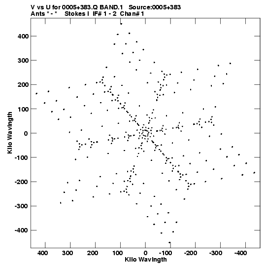
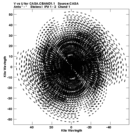
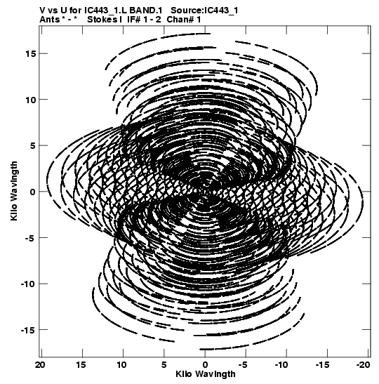
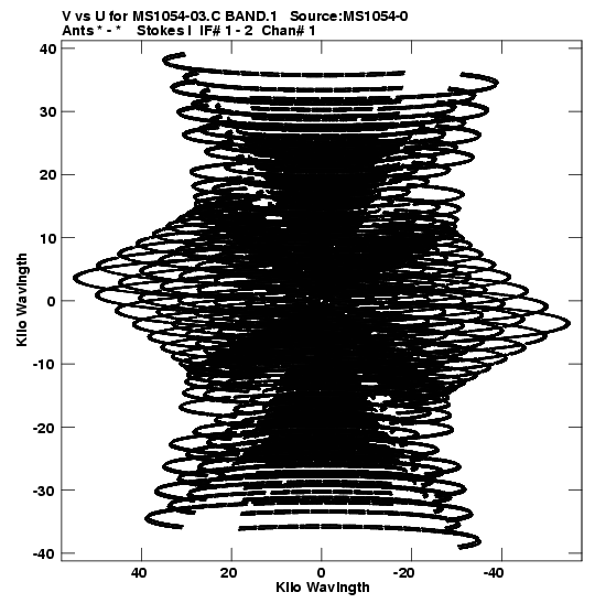
- UV-coverage: the part of the fourier plane that is measured
in the observation. The better filled this plane is, the more
information about the spatial structure of the source is measured. For
example, snapshots will show the typical snowflake pattern for the
VLA, whereas full 8-hour tracks, e.g., will show full ellipticals for
northern declination sources (and horizontally extended ellipses
around the central part of an hourglass shape for southern declination
sources). Snapshots may lack displaying the detailed spatial structure
of the source. Large holes around (u,v)=(0,0), whether snapshots or
full 8-hour tracks, will not image the diffuse extended emission; the
array is insensitive to this extended emission and thus acts, as one
says, as a spatial filter for extended emission. The latter is typical
for the longest A-, and B-array baselines, which can be complemented
by the shorter C-, or D-array configurations or with single-dish
observations.
| Remarks | UV-coverage Plot |
| Typical snapshot UV-coverage. Note the very low density of points, and the zero-spacing gap at (u,v)=(0,0) which all have.
|  |
| Long track on a northern declination source (north of about 34 degrees, the VLA latitude).
|  |
| Long track on a low declination source (positive, but below about 34 degrees).
|  |
| Long track on an equatorial declination source. Note how the tracks are near-horizontal.
|  |
| Long track on a southern declination source. Note how the top and bottom tracks turned concave.
| 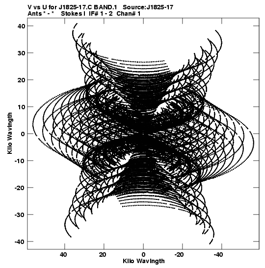 |
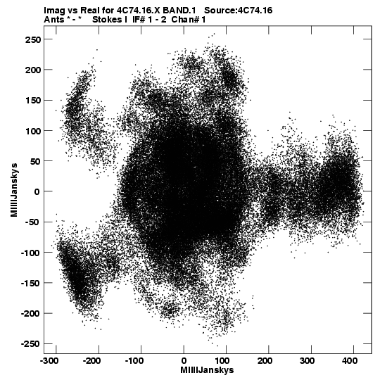
- Re-Im Plot: the calibrated data should yield, in a simple
case of a point source in the center of the field, a physical source
visibility Amplitude (the source flux density) and zero Phase. So for
properly calibrated data, this complex visibility translates in the
Re-Im Plot to data points around the flux density of the source on the
horizontal (Re) axis as the phase is zero. If the data are poorly
calibrated in amplitude, if there is a high noise contribution, the
scatter in radial direction will be large. Unfortunately, complex sources
that are well calibrated will also show this scatter. If the data are
poorly calibrated in phase, the scatter will be in phase. The latter
shows up as a curvature of the data points (vertical and toward the origin),
filling a larger segment at the flux density on the horizontal axis of an
arc around (0,0) when phase errors get larger. The more restricted the data
points are in area, the better the calibration. The avarage value of
the data points on the Re (horizontal) axis is the total flux
density of the sources in the image, so non-detections will show up as
scatter around (0,0). Be aware of self-scaling, watch those
(horizontal) axes!
| Remarks | Re-Im Plot |
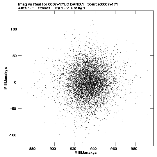
| Good, well calibrated data; "dense" and "confined" (Note the horizontal scale)!
|  |
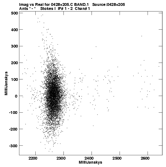
| Reasonably well calibrated data, can benefit from extra self-calibration. Phase
self-calibration will confine the vertical leftward-curved arc to the horizontal Im=0 axis.
Amplitude self-calibration will confine the radial spread to the Re="flux density" (2.25 Jy) value.
|  |
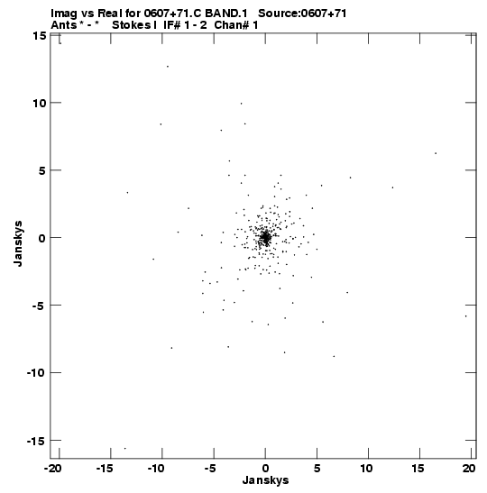
| If you ever see one of these (or when in doubt) Contact us A.S.A.P.!
|  |
| Of course there are some complex structures which are real and not due to bad data; the image will show an extended source or a combined response to many sources.
|  |
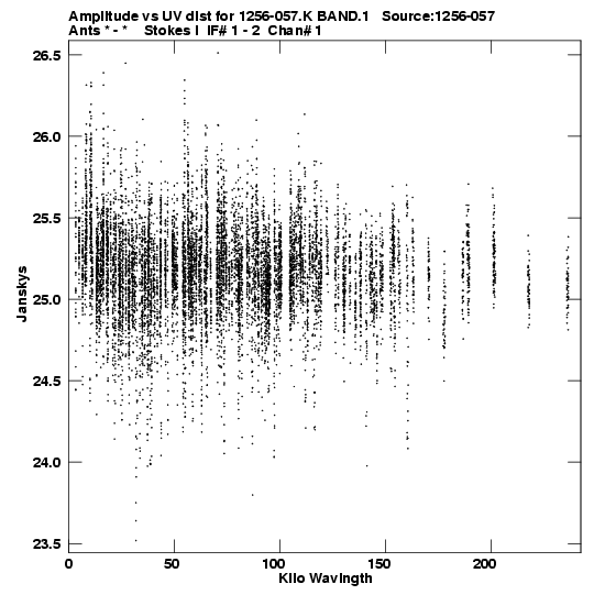
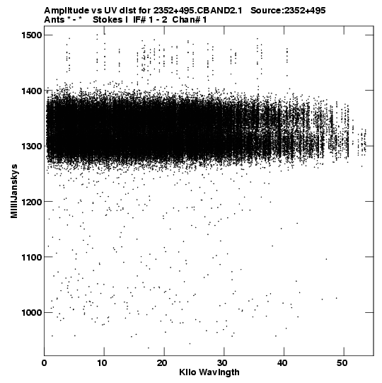
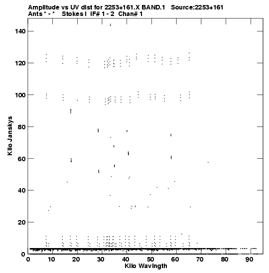
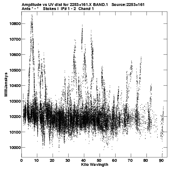
- Visibility Plot: the visibility amplitude versus baseline
length (in wavelengths) is a measure of the structure of the source. A
point source, which has no structure, will show up as a horizontal
distribition of the visibilities. The total flux density of the
sources in the image is where the data points would intersect
the amplitude (vertical) axis. Remember that interferometers
never actually measure this zero-spacing visibility, where
(u,v)=(0,0). Extended sources will have less response on the longer
baselines, i.e., the visibility amplitude decreases with baseline
length, whereas equal double point sources will have both the total
flux density and null amplitude responses. Non-detections, but also
faint detections, will show up as visibilities just above zero
amplitude where no information on structure can be deduced because it
will be burried in the visibility noise. Besides source structure,
these plots make it easy to recognize bad data points. Be aware of
self-scaling, watch those (vertical) axes!
| Remarks | Visibility Plot |
| Good, well calibrated data; "dense" and "confined" (Note the vertical scale)!
|  |
| Reasonably well calibrated data, can benefit from extra flagging of bad data. Bad data is on either
(upper and lower) side of the two horizontal dense distributions. When the source flux density in the two
VLA IFs (observed continuum bandwidths) is more equal, the double distribution will merge into a
single horizontal distribution.
|  |
| If you ever see one of these (or when in doubt) Contact us A.S.A.P.!
|  |
| Of course there are some complex structures which are real and not due to bad data; the image will show an extended source or combination of many sources.
|  |
NVAS Contact
Contact Lorant Sjouwerman
for any remarks, suggestions and/or reasonable complaints. Compliments and encouragements should
go to the division head (C. Chandler).
Thanks for using this service!
Back to the
NRAO VLA Archive Survey Images Pilot Page
|