Seeds: Chapter 2
Next Lecture - Cycles of the Sky, the Ecliptic, and Seasons
AstroNews: The Hubble Deep Field
The Hubble Space Telescope (HST) is the premier instrument for high-resolution optical imaging for astronomy in the world. By being above the Earth's atmosphere, the HST can avoid the blurring and twinkling effects caused by the turbulent motions and patchiness in the atmosphere that limit the performance of ground-based telescopes (even those on high mountaintops). A normal ground-based telescope operating in the visible wavebands of light is limited to a resolution, or how small a detail in a celestial object that it can resolve, of about 1 arc-second. Special computer-controlled optics are currently being developed that can compensate for the atmospheric effects, but these have yet to produce images with resolutions much better than 0.3 arc-seconds. The HST, on the other hand, operates at its diffraction limit of 0.1 arc-seconds.
Although nearly all of the observing time available on the HST is allocated to research astronomers or groups of astronomers, some time is reserved for the director's discretion, to be allocated to a special project or projects that were deemed to be unique, in need of a large amount of observing time, and would benefit the astronomy community as a whole. In 1995, it was decided that the bulk of this time would be devoted to imaging a single field for over 150 HST orbits. By spending a large amount of time on one pointing in the sky, exquisite sensitivity could be reached allowing high-resolution images of the faintest objects to be made. The Hubble Deep Field (HDF), as this project was called, was observed in November 1995 for 10 consecutive days with 155 HST orbits. The HDF itself is located in the constellation of Ursa Major (which contains the asterism of the "Big Dipper"), and was selected to be an unremarkable patch of sky (without bright galaxies or stars) pointed in the direction away from the plane of our galaxy.
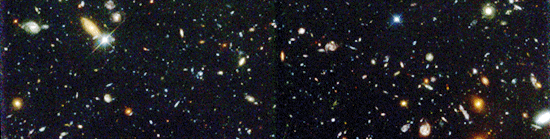
The HDF images are striking, showing myriad galaxies of all shapes, sizes, and colors. Galaxies as faint as apparent visual magnitude of 30 can be seen in these images. Although objects this faint or fainter can more easily be seen with the new large ground-based optical telescopes such as the 10-meter diameter Keck Telescope in Hawaii, only the HST can show these very faint objects with the superb clarity available from a space telescope.
Q: It was remarked that the magnitude limit of the HDF was around 30th magnitude. How many times fainter is this than the naked-eye visual limit at a reasonably dark site on the ground (approximately 6th magnitude)? This problem appears in Problem Set #1.
Before the telescopic age in astronomy, the stars and planets visible to the naked eye were all that were known. Because our eyes and brains are adept at pattern recogition, the ancient star-gazers formed the brightest stars into patterns, or constellations, that represented animals, heroes, and gods. Today, there are 88 recognized constellations, of which 48 are those constellations recognized by the Babylonians, Greeks and other early civilizations. The modern constellations nominally "contain" all the stars or other objects in their demarcated zones, much like the various States in the US are said to "contain" all that lies in their boundaries.
Early star atlases were gloriously ornate, with exquisite drawing of the figures that the constellations were meant to represent. Here are some pictures from some of the best known Celestial Atlases, or Atlas Coelestis: from Cellarius (c.1660), and from Flamsteed(c.1729). These were taken from the WebPages of the British Library.
Brightness and Apparent Magnitudes
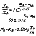
The Greek astronomer Hipparchus first systematized the visible stars by placing them in six classes ("first class", "second class", etc). This grew into the magnitude system for apparent brightness. Over the 6 magnitude classes that roughly cover the visible stars, the intensity varies by a factor of around 250. This gives rise to the peculiar system where 2.5 magnitudes equals a factor of 10 in brightness, and that larger magnitudes mean fainter stars. This is a logarithmic scale where
gives the relation between the intensities I_A and I_B for two objects A and B with apparent magnitudes m_A and m_B. This is not the first time we will encounter strange and confusing systems of measurement in astronomy!
Here are the apparent visual magnitudes for some representative astronomical objects:
| Object | Apparent Magnitude |
|---|---|
| Sun | -26.5 |
| Full Moon | -12.5 |
| Venus (at brightest) | -4.4 |
| Mars (at brightest) | -2.7 |
| Jupiter (at brightest) | -2.6 |
| Sirius (brightest star) | -1.4 |
| Canopus (second brightest star) | -0.7 |
| Vega (zero of scale) | 0.0 |
| Spica | 1.0 |
| Naked-eye limit (urban areas) | 3 - 4 |
| Uranus | 5.5 |
| Naked-eye limit (rural areas) | 6 - 6.5 |
| Bright Asteroid | 6 |
| Neptune | 7.8 |
| Limit for typical binoculars | 9 - 10 |
| Limit for 15cm (6in) telescope | 13 |
| Pluto | 15 |
| Hubble Deep Survey | 30 |
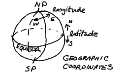
We now set up the coordinate systems that we use to map the positions of stars, planets, and other astronomical objects on the sky. We will start with the geographic coordinate system of the Earth globe. We are used to thinking about the Earth as a sphere, with a rotation axis that passes through the surface at the North and South geographic poles. The circle of the equator marks the plane perpendicular to the Earth's axis and divides the Earth into the northern and southern hemispheres. The postion of any point on the globe is given by the latitude, measured in the plane containing the point and the Earth's axis, in degrees running from +90 to -90 (north to south), and the longitude measured from the prime meridian (Greenwich meridian) on the constant latitude circle containing the point and parallel to the equator, in degrees 0 to 180 East or West of the prime meridian.
The celestial coordinate system for defining the positions of stars and such are just extensions of the geographic coordinate system. One could think of stopping the rotation of the Earth in some convenient place in its orbit, then projecting the position of any star down onto the globe's surface on the radial line outward from the Earth's center. This is what is meant by the celestial sphere, and it is usually pictured as a larger sphere containing the Earth and concentric with the Earth - every point on the Earth has a point directly above it on the celestial sphere, and every star on the celestial sphere has a point on the Earth directly below. On the celestial sphere, the North Celestial Pole (NCP) and South Celestial Pole (SCP) correspond directly to their geographic counterparts, as does the Celestial Equator. The coordinate system is also a direct analog, with declination (Dec) measured as the latitude is on the globe, and the right ascension (RA) corresponding to longitude - though for right ascension, the angle is measured in units of 0 to 24 hours from the zero-hour point. This is because rotation causes the place of the celestial coordinates above the Earthbound observer, so the right ascension of an object gives the number of hours since the zero-hour circle was at the same position in the sky.
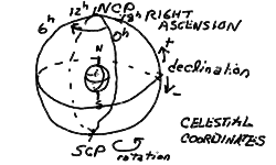
To define the celestial coordinate system, it only remains to fix the zero meridian of right ascension. We will define the position of the Sun at the vernal equinox to be at 0 RA (and at 0 Dec). The geographic coordinates then line up with the celestial coordinates at noon on the vernal equinox on the Greenwich meridian of the Earth. We will discuss this further when we come to the cycles of the Sun in the sky.
Because the celestial sphere is an extension of the geographic globe, we can also see that the stars with declinations equal to our latitude pass directly overhead. This is true for any observer. Someone on the equator sees the celestial equator overhead, and the NCP and SCP on the north and south horizon respectively. An unlucky astronomer stationed at the north pole sees the NCP overhead, and the celestial equator on the horizon. From this picture, it is easy to see that the angle that we see the NCP above the north horizon (since we live in the northern hemisphere) is just equal to our latitude. Philadelphia is at a latitude of nearly 40 degrees N, so the NCP is 40 degrees elevation above the north horizon.
Because the NCP is marked by a relatively bright star located less than a degree away - named Polaris, remarkably enough - it is easy to spot. Note that there is no such convenient "pole-star" at the SCP! Early navigators on the high seas could find their latitude by simply measuring the elevation angle of Polaris above the horizon using a sextant. Finding longitude, however, required an accurate reckoning of time, since the longitude is given by the time of transit of a given star on the observer's meridian (the north-south line overhead). Much of the boom in world naval exploration was due to the development of chronometers for navigation.
Daily Activity and Assignments
David Rittenhouse (b.1732, d.1796), a contemporary of Ben Franklin, was America's, and Penn's, first astronomer. In addition to carrying out astronomical observations, Rittenhouse also used his clockmaking skills to construct orreries, or working models of the solar system. One such Rittenhouse orrery is on display at the Van Pelt library, in the West wing on the ground floor (near the periodical section). Please take a look at it.

The first homework assignment is out! Problem Set #1 is due on Friday, 2 February 1996 at 5pm.
Go to Previous Lecture ---- Go to Next Lecture
Back to the Lecture Notes Index
Back to the ASTR001/Sec3 Page
Steven T. Myers - Last revised 23Jan96