 Early Astronomy --- | ---
Newton's Laws
Early Astronomy --- | ---
Newton's Laws
 Early Astronomy --- | ---
Newton's Laws
Early Astronomy --- | ---
Newton's Laws
Reading:
Chapter 1-2, Chapter 3-1, Prelude P-1 (ZG4)
 |
Key Question: | What observations led to Kepler's formulation of Copernicus' cosmology? |
|---|---|---|
 |
Key Principle: | Kepler's Laws of Planetary Motion |
 |
Key Problem: | What are the properties of a Keplerian elliptical orbit? |
 |
Key Quote: | "The heavenly motions are nothing but a continual music of several voices, which can be comprehended by the intellect, not the ear." - J. Kepler |
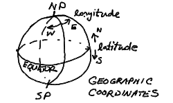
We wish to set up the coordinate systems that we use to map the positions of stars, planets, and other astronomical objects on the sky. We will start with the geographic coordinate system of the Earth globe. We are used to thinking about the Earth as a sphere, with a rotation axis that passes through the surface at the North and South geographic poles. The circle of the equator marks the plane perpendicular to the Earth's axis and divides the Earth into the northern and southern hemispheres. The postion of any point on the globe is given by the latitude, measured in the plane containing the point and the Earth's axis, in degrees running from +90 to -90 (north to south), and the longitude measured from the prime meridian (Greenwich meridian) on the constant latitude circle containing the point and parallel to the equator, in degrees 0 to 180 East or West of the prime meridian.
The celestial coordinate system for defining the positions of stars and such are just extensions of the geographic coordinate system. One could think of stopping the rotation of the Earth in some convenient place in its orbit, then projecting the position of any star down onto the globe's surface on the radial line outward from the Earth's center. This is what is meant by the celestial sphere, and it is usually pictured as a larger sphere containing the Earth and concentric with the Earth - every point on the Earth has a point directly above it on the celestial sphere, and every star on the celestial sphere has a point on the Earth directly below. On the celestial sphere, the North Celestial Pole (NCP) and South Celestial Pole (SCP) correspond directly to their geographic counterparts, as does the Celestial Equator. The coordinate system is also a direct analog, with declination (Dec) measured as the latitude is on the globe, and the right ascension (RA) corresponding to longitude - though for right ascension, the angle is measured in units of 0 to 24 hours from the zero-hour point. This is because rotation causes the place of the celestial coordinates above the Earthbound observer, so the right ascension of an object gives the number of hours since the zero-hour circle was at the same position in the sky.
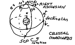
To define the celestial coordinate system, it only remains to fix the zero meridian of right ascension. We will define the position of the Sun at the vernal equinox to be at 0 RA (and at 0 Dec). The geographic coordinates then line up with the celestial coordinates at noon on the vernal equinox on the Greenwich meridian of the Earth. We will discuss this further when we come to the cycles of the Sun in the sky.
Because the celestial sphere is an extension of the geographic globe, we can also see that the stars with declinations equal to our latitude pass directly overhead. This is true for any observer. Someone on the equator sees the celestial equator overhead, and the NCP and SCP on the north and south horizon respectively. An unlucky astronomer stationed at the north pole sees the NCP overhead, and the celestial equator on the horizon. From this picture, it is easy to see that the angle that we see the NCP above the north horizon (since we live in the northern hemisphere) is just equal to our latitude. Philadelphia is at a latitude of nearly 40 degrees N, so the NCP is 40 degrees elevation above the north horizon.
Because the NCP is marked by a relatively bright star located less than a degree away - named Polaris, remarkably enough - it is easy to spot. Note that there is no such convenient "pole-star" at the SCP! Early navigators on the high seas could find their latitude by simply measuring the elevation angle of Polaris above the horizon using a sextant. Finding longitude, however, required an accurate reckoning of time, since the longitude is given by the time of transit of a given star on the observer's meridian (the north-south line overhead). Much of the boom in world naval exploration was due to the development of chronometers for navigation.
I would like to demonstrate that even if the Earth were locked facing the Sun so that it was always the same solar time, that the celsestial sphere, and thus the distant stars, would be seen to rotate once during the year. Shown below is a rough diagram illustrating two differently colored hemispheres of the Earth locked facing the Sun. Note that the dark colored half rotates once relative to our point-of-view of the stars.
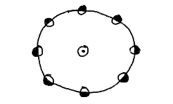
Thus, even if there is no solar day, there is one sidereal day. We now draw the same figure, but with the dark half making two turns with respect to the stars (us looking down on it).
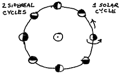
We now see that our "Earth" makes one complete rotation with respect to the Sun, as the white half faces the Sun at the right, and the dark at the leftmost part of the orbit. The year now is one solar day long, but two sidereal days long! It is easy now to see how this will generalize to more days. Q: Try drawing the same picture for 3 sidereal days in the year (Hint: divide the orbit up into 12 earths on the orbit instead of 8). There will always be one more sidereal rotation than solar rotation. If there are 365 solar days in the solar year, then there will be 366 sidereal days in the solar year. Thus, the solar day must be (366/365) x sidereal day!
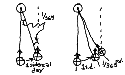
I will now make a third set of drawings to show the relationship between the sidereal and solar day. I will zoom in on a (greatly exaggerated) step of one day in the orbit of the Earth. We see on the left panel, after one sidereal day, the earth is in the same orientation to us (the stars) as it was at the beginning. The little arrow meant to represent an observer looking upward is pointing in the same direction. But note that at the end of the day it is no longer pointing at the Sun! This is because our orbit has carried us around a little ways, and the Sun now appears in a different direction (a little eastward). To bring our arrow to point at the Sun again, we have to move a fraction of a rotation farther. From geometry, we know that the angle between the first earth, the Sun, and the second earth, which is just 1/365 of a circle (the orbit), must be equal to the angle between the Sun, the second earth, and the direction to the distant star the second arrow is pointing to. This is 1/365 of a circle then, or 1/365 of a sidereal day (a circle of the earth). Thus we get the panel on the right:
This also shows the importance of drawing pictures to help you understand the geometrical aspects of astronomy. This will become very useful also for understanding the phases of the moon and eclipses.
Prev Lecture ---
Next Lecture ---
 Astr11 Index ---
 Astr11 Home
smyers@nrao.edu Steven T. Myers